website watertownhistory.org
ebook History of Watertown, Wisconsin
Milwaukee-Watertown
Plank Road
Construction
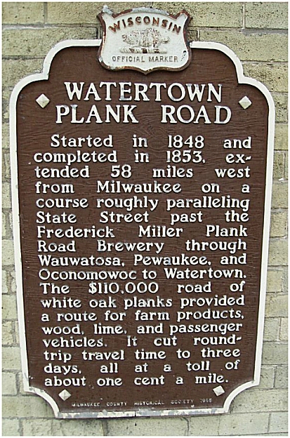
began in 1848 and it was completed in 1853
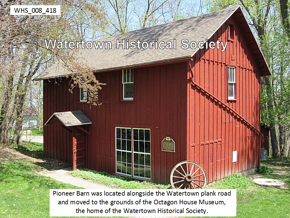
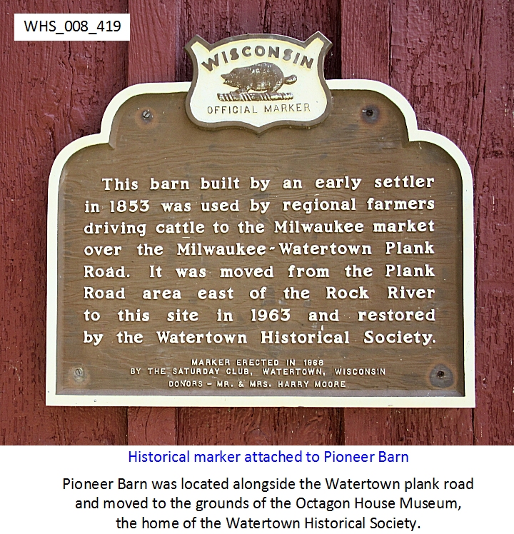
Watertown Plank Road Barn
The building of roads to open the
country for settlement and military purposes was one of the first concerns of
the settlers and the government.
Following old Indian trails, a Milwaukee-Watertown wagon road was
constructed in 1837. Later this was
planked and ultimately became Federal Highway 16 (sometimes
locally called the “Oconomowoc Road”).
_______________________________________
One of
the most innovative aids to the transport of goods in the early pioneer days
between Watertown and Milwaukee was the creation of the Plank Road, a wooden
highway that roughly conforms to US Highway 16 today. Started in the late 1840s, the road was
finished as far as Watertown in 1853.
Shipping goods before the invention of the plank road often took weeks
at a time, but after the road was completed, the time was reduced to a matter
of days. Known as the Milwaukee Plank Road in Watertown (and the Watertown
Plank Road when it left Milwaukee), the road came into Watertown via what is
today Oconomowoc Avenue, and turned onto Concord Avenue, then to Main
Street. The road, originally a toll
road, was abandoned with the arrival of the railroad in 1855 and was gradually
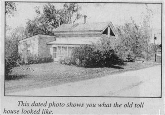
taken apart and the logs discarded. The last toll house in Watertown, which
stood along Oconomowoc Avenue, was torn down in 1999.
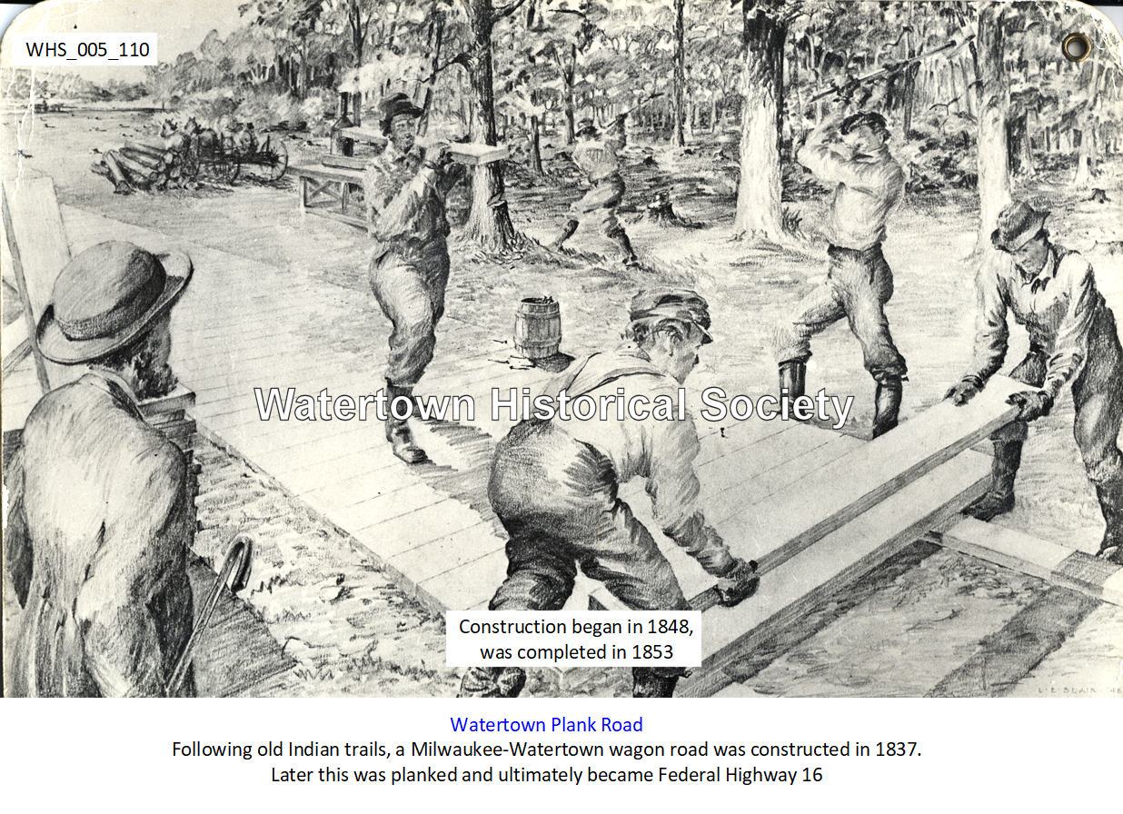
Image WHS_005_110
During the first few years, whenever we had to buy supplies, two of us
would go together—of course on foot— [from Lebanon] to Watertown and carry them
home on our backs, a distance of seven miles or more . . . Very soon we laid
out a road to Watertown. Wherever the
ground was soft, we laid trunks of trees as foundation, forming what the
Americans called a ‘plank road’ . . . At one time I worked with others from Lebanon on the
Milwaukee-Watertown Plank Road, between Ixonia and Watertown. We put down logs. Fifty years later, in the spring, I drove over
the same stretch and there I saw traces of the old foundation. [Reminiscence of Ernst Gottlieb Dornfeld (1831-1907),
“My Home Town”, Charles Werth, published in Lebanon
Leader of 03 1995]
PLANK ROAD MAP
PLANK ROAD TOLL LEDGER
PLANK ROAD BARN
WATERTOWN: “SECOND CITY” IN WISCONSIN,
PLANK ROAD BONANZA FOR LOCAL TAVERNS
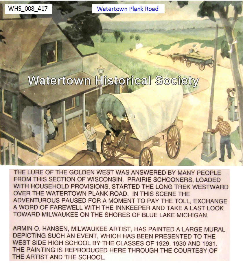
“After the completion of the plank road, Watertown, early a place of
promise, became the second city in the State and a bonanza
for taverns; their story, however, has been well told in local
histories. People and produce from the
country to the west and north for many miles PASSED THROUGH WATERTOWN TO
MILWAUKEE, and land seekers made it their headquarters. J. B. Van Alstine,
for years the popular landlord of the Exchange, declared that he thought
business dull in those palmy days unless he had a hundred guests and as many
horses to care for. Two of the old
taverns are still running [in 1915], the Watertown
House, now the Commercial, and the Buena
Vista, which was opened in February, 1848, by Capt. Henry Bogel, a veteran
of the Mexican War. During the regime of
William Wiggenhorn and his son, Eugene, the Buena Vista was the rendezvous of
German revolutionist refugees, among them Carl Schurz and Emil Rothe, while on
Sundays German services were held in its hall.” Derived from “The Taverns and Stages of Early Wisconsin” by J. H. A. Lacher,
1915.
1844-1853
Watertown
Daily Times, 30 and 31 Dec 1986
The first mention of a plank road for Wisconsin occurred in 1844 when a
road was proposed from Milwaukee to Prairieville (Waukesha) or Mequanigo (Mukwonago). This proposal did not receive too
much attention, and it was not until 1846 that the first of 133 plank road
charters was granted. It was given to the Lisbon and Milwaukee Plank Road
Company by the territorial legislature which authorized it to capitalize at
$50,000. The road was to be constructed of timber and plank, "so that the
same form a hard, smooth and even surface," from Milwaukee to Watertown or
any part of the way.
Interest in the proposed road soon lagged, but when residents of
Watertown held a "plank road ball" in the American
House there in February, 1848, and when extensive rains came that spring,
making dirt roads almost impassable, subscriptions of stock in the plank road
company picked up and the total stock issue of $50,000 was subscribed.
An amendment to the road company's charter was approved by the
territorial governor on March 1, 1848, changing the name of the company to the
Madison, Watertown, and Milwaukee Plank Road Company, and authorizing an
increase in capitalization to $300,000.
James D. Doty was elected president and Alexander Mitchell treasurer.
On August 8 the board let contracts for "grubbing," grading
and clearing ten miles of the road between Watertown and Oconomowoc, but
interest tagged again until a new meeting was called and Elisha Eldred was
elected president. Alexander Mitchell
remained as treasurer; William A. Prentiss was
elected secretary. Eldred became the
driving force behind the project.
Contracts for the actual construction of the road were let in October of
1848, and work was in full swing by the next month, though the amount of cash
on hand, due to the installment payment plan for stock subscriptions, was
probably between $12,000 and $13,000. The cost of a plank road was about $2,000
a mile. Wisconsin residents were lacking in capital but this could be overcome
by having farmers along the route take small stock subscriptions and pay for
them in material and labor. Experience of plank road builders in central New
York state led Wisconsin promoters to expect 25%. if not 50% earnings on stock.
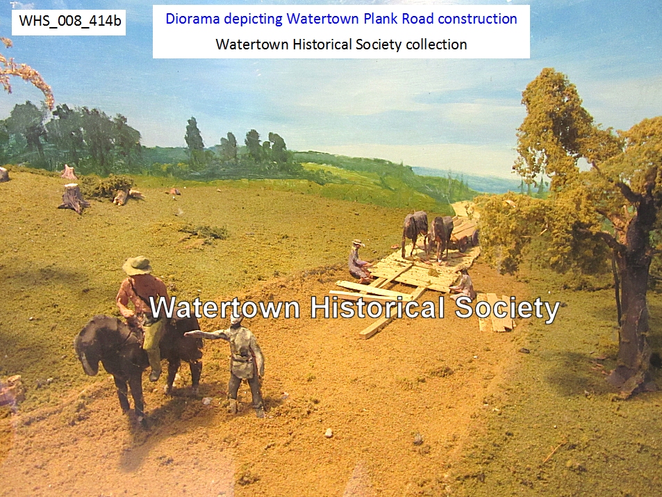
Plank roads are basically just what the name implies. The first
construction step was the clearing and grubbing. In flat land the trees,
stumps, roots, and other obstructions were removed from the width of road.
After the roadway was cleared, it was graded for a width of 24 feet
between ditches. The center of the road was raised six inches higher than the
sides with a gradual inclination to the ditches. Before the actual grading was
done, the roadway was ploughed to a depth of eight to twelve inches and
thoroughly dragged to pulverize the earth.
The stringers, upon which the planks were laid, consisted of white oak
boards, one and one-half inches thick, eight inches wide, and not less than
twelve feet long. They were laid in trenches so that the upper surface of the
stringer was level with the earthen road bed. The outside stringer was set one
and one-half inches lower than the other, and eight feet in width was allowed
between the two, though in portions of the road near Milwaukee the stringers
were laid 12 feet apart. The space between stringers was filled with earth to
one-half inch above the surface of the stringer.
The one remaining step was the placing of the actual planks. They
consisted of oak boards three inches wide and eight feet long. They were placed
on top of the stringers and pounded down with a heavy maul until they rested on
the stringer. The planks were not nailed down or fastened in any other manner.
This proved a disadvantage when the road was engulfed by high water, as the
planks would float away. It was done because nails or similar objects would
work loose and injure horses' hooves.
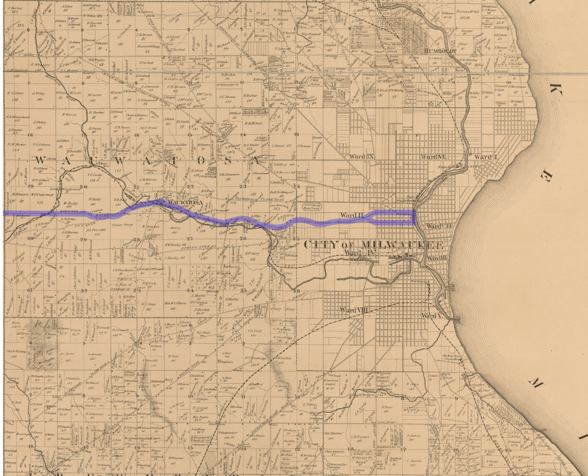
The road mainly followed the old
Madison Territorial road. In Milwaukee there were two forks. Traced
on a modern day map of Milwaukee and vicinity, the north fork would begin at
12th place and Juneau avenue, the south fork at 11th street and Kilbourn
Avenue. The two forks would come together at what is now 15th and Highland
Boulevard. The road zig-zagged to 35th street and then followed State street
into Wauwatosa. Crossing the Menomonee river on the Harwood Avenue bridge, the
plank road continued westward through Elm Grove on a route still known as the
Watertown Plank road, connecting with the Bluemound Road at the Durkel house. Winding along the Bluemound Road to Goerke's
Corners and then northwest along County Trunk SS over the Pewaukee and Fox
rivers to Pewaukee, the planked thoroughfare continued on the old U.S. Highway
16 and crossed the Oconomowoc and the Rock rivers before entering Watertown.
Once the work on the road was begun, it continued without any serious
interruptions. By 1849 ten miles of the road were in use near Milwaukee, and
the portion between Oconomowoc and Watertown was graded and grubbed.
In September of 1849 the board closed the books to additional stock
subscriptions. Although there is no definite record of how many shares were
sold, the Milwaukee city directory of 1854 listed the capital stock at
$105,460. At $10 per share, this would indicate 10,546 shares. These were sold
to an unknown number of stockholders, but by November of 1850 the total stock
was held by 70 persons.
By the end of 1850, 38 miles of the road were either planked or well
graveled. In June of '53 the road was finished to the bridge in Watertown. The
new road was 58 miles long, the longest plank road in Wisconsin. Its reports
were, without exception, favorable, and it was labeled "one of the best
laid roads in the Union." The only disrupting influence on the road
was excessive rain. Low grades were often submerged and planks floated away.
Generally, however, the company was prompt in repairing these breaches.
The cost for the 58 miles was approximately $103,000, not including toll
houses, bridges, etc. which would raise the total to almost $110,000.
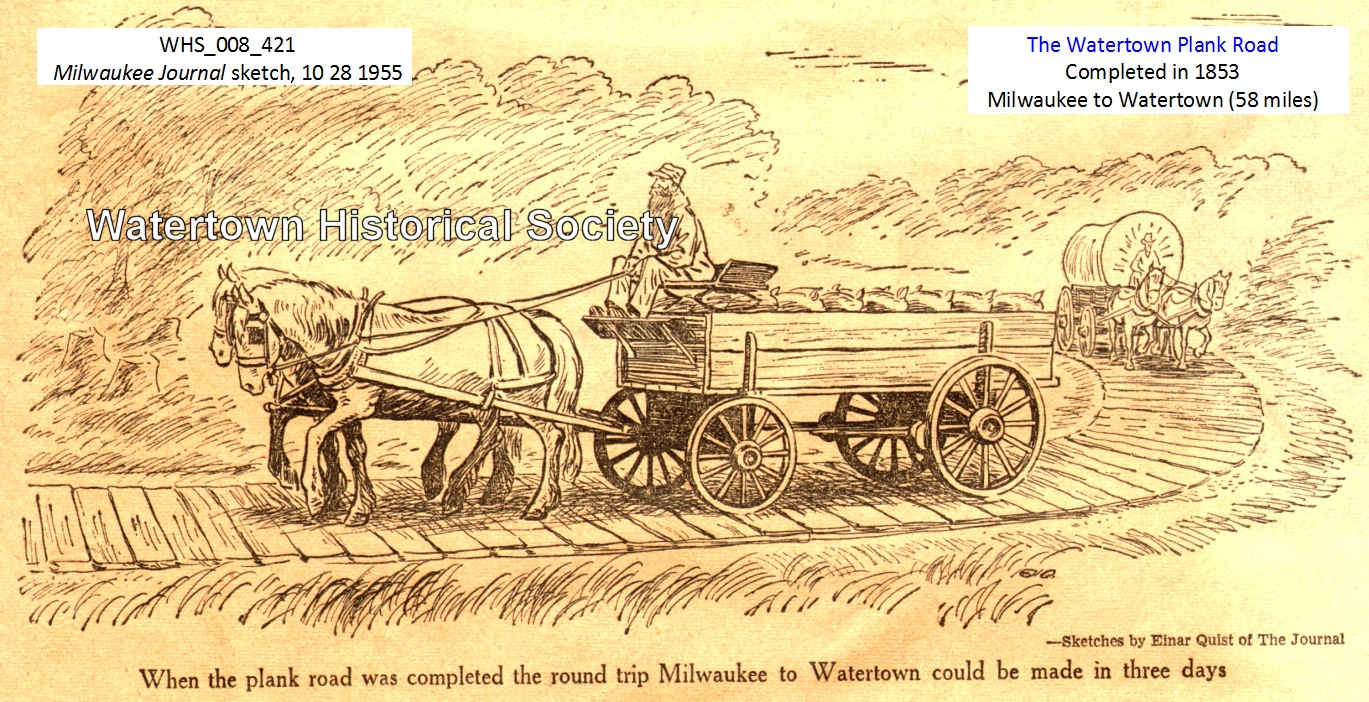
The road was highly successful. Before it was constructed the round trip
from Milwaukee to Watertown required four days in good weather, six days in
bad. Loads varied from 1,500 pounds to 2,000 pounds, depending on the condition
of the road. After completion of the road, the time needed for a round trip
decreased to three days and the average load increased to 3,000 pounds,
regardless of the weather. This combination of shorter time and larger loads
cut freight rates about 25%. For example, the cost of transporting building
stone, from a quarry 4 1/2 miles to Milwaukee dropped from $9.50 to $7.50 per
cord.
What was hauled over the new road?
Wheat was by far the leader in Milwaukee-bound loads though wood and
lime were brought here in fairly large quantities.
A tabulation on the traffic for three days, Oct 31, Nov. 1 and 2, 1849
was published in the Milwaukee Sentinel and Gazette of Nov. 8, 1849. The
breakdown for loads coming into Milwaukee was as follows:
|
|
|
Oct 31 |
Nov. 1 |
Nov. 2 |
|
Wheat |
Loads |
121 |
165 |
134 |
|
|
Bushels |
5,156 |
6,600 |
5,460 |
|
Barley |
Loads |
13 |
17 |
15 |
|
|
Bushels |
520 |
680 |
600 |
|
Flour |
Loads |
7 |
12 |
5 |
|
|
Barrels |
70 |
120 |
50 |
|
Corn |
Loads |
|
|
1 |
|
Potatoes |
Loads |
|
1 |
1 |
|
Wood |
Loads |
7 |
14 |
9 |
|
Lime |
Loads |
4 |
5 |
6 |
Traffic going out of Milwaukee was just about double that coming in. The
breakdown of loads was as follows:
|
|
Oct. 31 |
Nov. 1 |
Nov. 2 |
|
Merchandise |
37 |
47 |
45 |
|
Family Goods |
13 |
17 |
18 |
|
Lumber |
15 |
33 |
16 |
|
Carriages |
28 |
51 |
49 |
|
Empty Wagons |
57 |
57 |
74 |
Not only did haulers benefit from the new road, but stage travel
increased three fold and tolls from pleasure vehicles were reportedly enough to
pay upkeep.
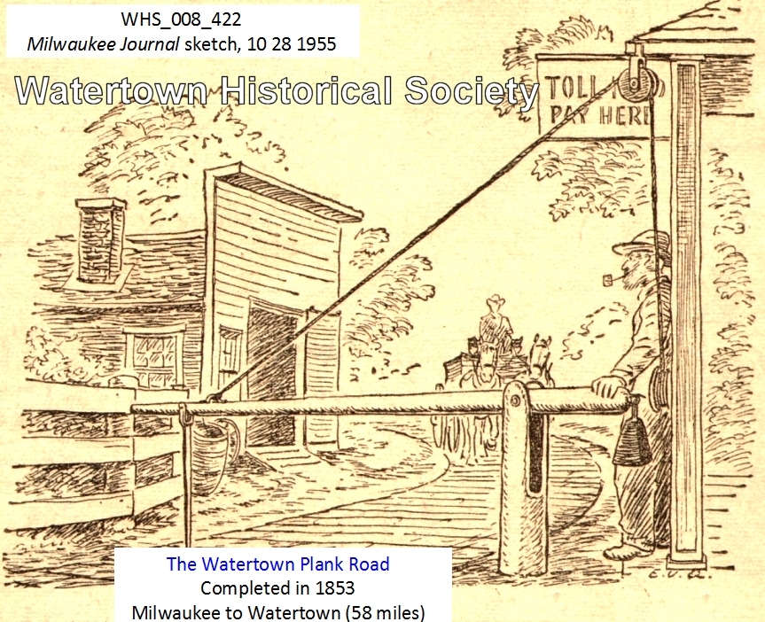
With the completed road in use, the company erected toll gates at five
mile intervals. One gate was a short distance east of Hartland, and another
between Nashotah and Okauchee. This pattern allows
for gates near Watertown, at the crossing of the Rock River, near Oconomowoc,
at the bridge over the Fox River, and at the Dunkel house. The gates nearer
Milwaukee were constructed independently of the others, to benefit from the greatest
traffic. (As late as 1892 there was a gate where the plank road intersected
35th street, and another near what is now the County poor house.) Tolls
averaged $600 per week when the road was completed. The basic toll was l
cent per mile for every animal drawing a vehicle although the total fare for a
one-way trip over the 58 miles was 66 cents.
A dividend to stockholders of 7% was declared on January 1, 1852 and
others of similar amount followed until 1855. There was no public notice of any
dividends in the following years, but in this period annual earnings were
reaching 25%.
The stockholders of the Madison, Milwaukee and Watertown Plank Road
Company might well have read the Milwaukee newspapers of February 25, 1851 with
alarm. For on this day the Milwaukee and Mississippi railroad was completed to
Waukesha, a sign of the far greater competition to follow. That competition was
not slow in coming, for the Milwaukee and Watertown railroad was completed to
Watertown in 1855.
With the coming of the railroad, the plank roads in general, and the
Watertown road in particular, passed into obscurity. Milwaukee newspapers
contained practically no mention of the road after the railroad was completed
in 1855.
Many of the stockholders of the plank road, however, were active
promoters of the railroad. Elisha Eldred, the president of the Watertown plank
road, and Eliphalet Cramer, a member of the board, were also members of the
board of directors for the Milwaukee and Watertown railroad. Other promoters
and stockholders of the plank road who were active supporters of the railroad
included Alexander Mitchell, Joshua Hathaway, William A. Prentiss, James
Rogers, Hans Crocker and Levi Blossom.
In 1863 the plank road was depicted as being in wretched condition. It
was "broken and dilapidated" and "dangerous to drive
over." It was transferred from private to public ownership after the
legislature of 1887 authorized such action.
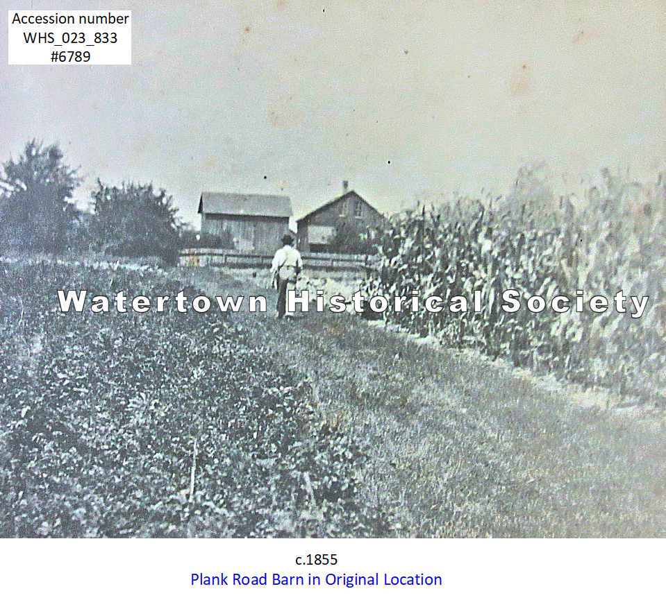
WHS_023_833
1851
06 09 PLANK ROAD PLANKS FLOATING AWAY
Stage Coach Runs
Rerouted
Between
here and Milwaukee the Plank Road is in an awful condition. The planks have floated off, and in some
places the water is waist deep. This
side of Oconomowoc, the water, we understand, covers the road some distance.
The
Stages have resorted to the old road by Kellogg's, as they get along better. The great amount of water which has fallen
since Saturday last has raised the streams and flooded everywhere in the low grounds.
Many
fields of potatoes have either washed out of the ground or are rotting from the
excessive moisture.
The
watery elements appear to have taken a lien upon the weather and are having it
all their own way. Democratic State Register
09 15 ROADS, RAIL AND PLANK
. . With [both] the plank road and railroad
from Milwaukee to this place, Watertown, with its central location, must become
the chief mart of the north and west.
Let us put our shoulder to the wheel and do our share, for where there
is a will there is a way, and we soon shall derive benefits incalculable from
these improvements. Watertown, possessed
as she is with its water power from the Rock river, and her beautiful and
eligible location, and industrious population, cannot fail to rank her among
the first of the inland towns of our State.
- Democratic
State Register, 09 15 1851
1853, PLANK ROAD
COMPLETED
Plank Road
to city of Watertown
05 28 1853
Watertown Weekly Register, “Official Paper of the City”
Local City News
City
Plank Road—It is well known by the most of our readers that the two plank roads
which are built from Watertown do not come into the city limits, but terminate
near the corporation line. This,
consequently, at some seasons of the year, leaves a piece of very bad road
between the termination of the planking and the business part of the city.
Pursuant
to a resolution of the Common Council of the city, a committee consisting of
Messrs. A. F. Cady, John W. Cole and S. Ford, was appointed to superintend the
grading and planking within the limits of the city.
Immediate
steps were taken by the committee and about 60,000 feet of plank contracted
for, and 40,000 feet more in course of negotiation, making in all 100,000 feet
of plank, delivered on the line of the road at $8 per thousand. The workmen commenced laying the plank on
Thursday last, and the connection will be made with the Milwaukee road during
the coming week.
The
road west of the [Main Street] bridge to the Western Plank Road, during the wet
season, is almost or quite impassible for loaded teams. As soon as possible, a gang of men will be
set to work and the plank laid, so as to give a continuous plank road through
the city. The Western company are
pushing on their work so that no hindrance will occur to teams in any kind of
weather.
Completion of the plank road gave farmers a choice of markets
We
have often extolled plank roads as a great convenience to the farmers though
they do have to pay for the privilege of travelling upon them. We have, however, been led to doubt their
advantage in a commercial point of view, when located between an interior
village and a lake port. They have a
tendency to carry away produce beyond us, when the policy would dictate to our
merchants to purchase here, and thereby secure the money which the farmer
disburses on selling his grain, instead of having it left in Milwaukee. A prospect of getting a few cents more in
price will induce many men to carry their grain to Milwaukee, over the plank
road. The only remedy for this state of things is a
railroad between these interior markets, and the lake towns. Farmers cannot compete with a railroad in
carrying grain, therefore they will find it to their advantage to sell at the
nearest R. R. depot. This consequently
induces a home market, and the money laid out for necessaries by the farmers
retained in the interior.
This
is what we want at Watertown. If our
theory is good in regard to plank roads from here to the Lake, it will prove
good when they are built from Watertown to the West, South-west, or North-west,
provided of course that we have a Railroad from here to Milwaukee. A farmer can never find it profitable to
carry grain to Milwaukee for six cents a bushel, when a railroad can. If, therefore, the building of plank roads
from Watertown into the country west, southwest and northwest, can be
accomplished, it will enable the farmers of those regions to find a ready
market at this point, and by purchasing their goods here they will materially
add to the prosperity of our city.
We
think if our city had loaned its credit for the building of a plank road from
here to Beaver Dam, and from here to Cambridge, in Dane county, that we should
have received a greater benefit than from the construction of a railroad from
here to Berlin, at the present time. We
should have enabled the farmers to get their grain to market at all seasons of
the year, and as every farmer has more or less to purchase, they would leave a
large amount of money in circulation among us, besides giving our splendid mills
a sufficient occupation, in manufacturing the wheat into flour.
DONATION OF HISTORICAL
MARKER BY SATURDAY CLUB
Three
years since, before the completion of the Plank Road, over 150,000 bushels of
wheat was purchased in this village in one season. We can account for the falling off only by
the fact that the completion of the plank road gave farmers a choice of
markets. They found they could pay the
tolls on the plank road and still make carriage to Milwaukee a matter of
profit, rather than sell here.
We
therefore hail the early completion of the Watertown Railroad as one of the
greatest moments to the prosperity of our city.
It will be the means of creating a large retail trade, and a commercial centre for a large extent of fertile territory.
Watertown Daily Times 4 and 11 Dec 1999 (Tom Schultz)
One of Watertown's historical landmarks disappeared from the scene last
Friday. It was a quiet death and was probably witnessed by only a handful of
people. And, for the most part local residents probably didn't really
recognize its significance.
We're talking about the old toll
house, which was the end point for the old Watertown Plank Road back in
the 1850s. The toll house had stood at
the same location on East Gate Drive for nearly 150 years, collecting tolls
from people traveling along the route between Watertown and Milwaukee and all
points in between.
The old toll house was located on the south side of East Gate Drive, a
little ways past the little inlet to the Rock River. The property has river
frontage and it's only a couple thousand feet east of Settler's
Bay, also on the Rock River.
That was the best possible way to travel back in those days. It reduced
travel times between Milwaukee and Watertown by about one-half. Before the road
it took about six days and after it was constructed the trip could be made in
three to four days.
What happened to the landmark? Well, first of all, it was never
registered as a national historic place, and it really had little value other
than as a home to the owners, Randy and Gloria Kuckkan.
The Kuckkans, who are the owners of Firehouse Lanes,
Bar and Grill on North Water Street (another historical building, but we'll get
into that another time), had lived in the old toll house for the past 25 years.
Several years ago they made a decision to have the building razed and the
property used as the site for their new home.
That's exactly what happened last Friday. The wrecking crew came in and
razed the home and construction of the new one is already under way.
Although the home is not in the city limits and the original building is
now gone, it might be nice for the city and/or the Watertown Historical Society
to see if somehow there could be a small plaque erected that would note the
significance of the site.
You know, after some generations, it's likely that site will become a
forgotten part of Watertown's rich history but, we'll leave that up to the Kuckkans and the historical folks as to whether or not that
is appropriate, and not just a nuisance for the Kuckkans.
We talked with Randy about the old home and he said there was really
nothing of significance that would tie the home to its original use as a toll
house. By the time they had acquired the building 25 years ago, any artifacts
had already been taken and preserved. For example, some of the original
financial books of the toll road are now at the Watertown Octagon House.
He said the one thing significant was the fact that the boards were all
nailed with the old style square nails. He added the building appears to have
had several additions over the years.
Many of our readers probably don't have a good knowledge of the old toll
road, and because of this change in the local landscape, this might be an
excellent time to review the history.
First of all you have to envision that most travel out this way back in
the 1850s was through openings in the thick forest or a winding path through
meadows.
This was a pretty primitive lifestyle back then. Remember, Timothy
Johnson first came on the scene in 1836 and we're talking less than 20 years
later. A lot of people were coming out this way back then, but progress was
slow.
Back in 1853 when the toll road reached Watertown, we were officially
chartered as a city rather than a village, and our population was listed at
4,000, the second largest city in the state.
The old toll road started in
Milwaukee and then traveled through Elm Grove and Goerke's Corners (now
the approximate location of 1-94 and Highway 18 in Waukesha County), along
County Trunk Highway SS to Pewaukee and then along the old state Highway 16
right of way through Hartland, Okauchee and
Oconomowoc before arriving along East Gate Drive on the city's east side and
ending at the old toll house where the tolls were collected.
The toll road back in those days was called the farmer's railroad. It
was used to bring produce and other products to this growing city. It was built
before it was feasible for railroads to be constructed out this far, and it
certainly was more economical that laying of tracks and
operating a train. But the train wasn't too far behind.
The story of the Watertown Plank Road goes back to 1846 when the Lisbon and Milwaukee Plank Road Company
received a plank road charter from the Wisconsin territorial legislature with
the road to be constructed between Milwaukee and Watertown or any part of the
way they deemed feasible.
Interest in the road grew a great deal in 1848 when some heavy spring
rains made travel on the old dirt paths almost impossible. Construction
actually began in November of 1848 at a
cost of approximately $2,000 a mile. Funds were raised through the sale
of stock in the company. Imagine, that was $2,000 a mile and today a freeway
costs several million dollars a mile and that's only if there's smooth sailing
and no bridges.
The total cost of the 58-mile road was $110,000 and it was completed in
1853.
The center of the road was about 6 inches higher than the sides. Before
grading, the roadway was plowed to a depth of 8 to 12 inches and was thoroughly
dragged to make the dirt more solid.
The plank road was built like a
sidewalk or a wooden floor. The stringers were 8 inches wide, 1 1/2
inches thick and 12 feet long, all of white oak. They were set 8 feet apart.
The outside stringer was about 1 1/2 inches lower than the other. The space
between the stringers was filled with dirt about a half an inch above the top
of the stringers, and then the surface boards were placed.
Only one-half of the road bed was planked. The half used for a
turnout was left in dirt. The oak planks were placed on top of the stringers
and on top of that was a half an inch of dirt. The planks were pounded down
with a heavy mall until they rested on the stringers. The planks were not
nailed. This was because the spikes would eventually work loose and be damaging
to the hooves of horses.
A lot of farmers along the way purchased shares of stock in the plank
road and paid for them with donated material and labor.
Work on the plank road went along at a rapid pace for that era. By 1848,
10 miles of the road near Milwaukee were completed and clearing was under way
all the way out to Oconomowoc. By the end of 1850, 38 miles were either planked
or graded and in June of 1853 the entire road was completed. It was the longest
plank road in Wisconsin and it was a real boon to the area. It cut travel
between Milwaukee and Watertown to three days as compared to up to six days
before the road. And, all it cost was about one penny a mile. Every five miles
there was a toll booth.
An old toll gate book from this house is preserved at the Watertown
Octagon House. It showed traffic on the plank road was divided into three
categories. One was passenger vehicles, another was freight vehicles and the
third was animals.
An entry for July 1, 1853, showed 11 passenger vehicles, each drawn by
one animal, at 5 cents per vehicle; 39 freight vehicles, each drawn by a single
animal, at 10 cents per vehicle; one freight vehicle pulled by four horses, 15
cents; three horses pulled or ridden, 3 cents each; and several other animals.
All in all, it was a pretty good day with receipts of $4.71. The highest weekly
total in that book was revenues of $89.03. Just about every day had note of a
stagecoach traveling on the road. The stagecoaches were not charged which leads
us to believe they were probably owned by the toll road company.
Back in the era when the road was constructed, that area from what is
now Lindberg's by the River east to the toll house was a village all by
itself. The whole city at that time consisted
of settlements and this one on the city's southeast comer was the largest.
On the southeast corner of Oconomowoc and Concord avenues was the
historic Boston House, a well-known
business. It included a large dance hall. Travelers over this section of the
plank road always looked forward to a stop at the Boston House.
Other places of interest in that settlement were the Wisconsin House, another hotel located
across the plank road from the toll house and now state Highway 16, Rasch Brewery, Wenzel Quis' store, and the Kadish store.
Part of the road which traveled through the city was also planked.
Watertown's Main Street back then was a tamarack swamp as was much of the
territory over which the road traveled and the planks were necessary for
travel.
As we were reading a little history on the toll road we were surprised
to see the road extended to Madison at one time. We didn't recall that leg of
the road. The report we read indicated travel was much lighter on that segment
because of the few settlements between Watertown and Madison.
Things were going quite well on the plank road until the trains arrived.
It was reported that back in February of 1851 the trains were in Milwaukee's
Menomonee Valley, and four short years later the Milwaukee and Mississippi Railroad entered Watertown. That changed the whole dynamic of
travel. Both freight and passengers could be moved
much faster by rail than by the Watertown Plank Road.
As we mentioned earlier, there were some Watertown investors in the
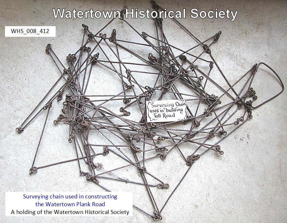
plank road venture. Among them was John Richards, builder of Watertown's famous Octagon House
[reportedly also surveyor for the plank road].
He was one of the directors of the company. William
A. Prentiss, a cousin of Watertown's first mayor, Theodore Prentiss, was
also a stockholder.
The name Watertown Plank Road is still preserved, having been used for a
modern blacktop and curb and guttered road in Milwaukee County. In addition, a
plaque marking the route of the plank road is located on one of the Miller
Brewing Company properties in downtown Milwaukee.
So, there you have the basics on the Watertown Plank Road and the old
toll house that was razed late last month.
Plank
Road Recalled
[Derived
from memories of August Moldenhauer,
recorded in 1935 at age 84]
In
about the year 1854 the Milwaukee-Watertown plank road was built. This was about 8 miles south of our
farm.
On
our trips to Milwaukee we used to take the plank road, for which a charge was
made of 2 cents each mile. Toll was
collected at the toll houses which were about 3 or 4 miles apart. Each toll house had a pole across the road
and you could not go through until your mile tollage was paid, either at each
place or you could show a ticket for your complete trip.
A
trip to Milwaukee was usually started at 12 o'clock at night and you would
arrive there at 4 o'clock in the afternoon.
Books
found listing tolls on Plank Roads
Watertown
Gazette, 09 10 1936
In
pioneer days, when roads consisted either of mere openings through the forest
or rutted trails across prairies, private companies built roads of plank. The only two toll books known to be in
existence in Wisconsin which were used in connection with the early plank roads
have been brought to the attention of the state historical society.
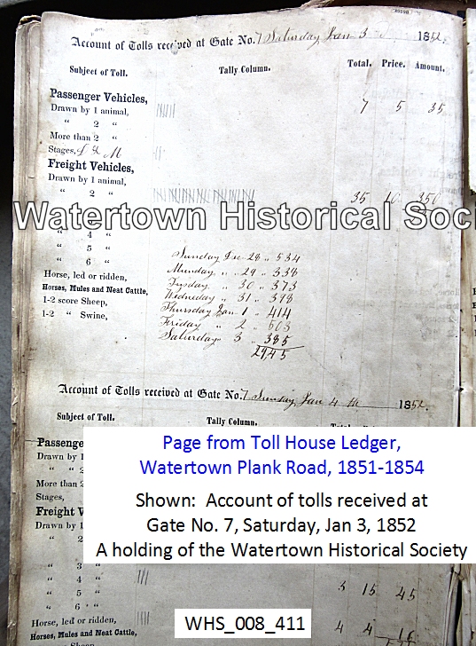
The
two toll books were used from 1851 to 1854 at gate No. 7 near Watertown on what
is now highway 19. They still carry an
interesting story in spite of the fact that they had been used as scrap books
for newspaper clippings by their owners, Nellie and Jennie Needham, one of whom
was born in the toll gate house.
Cross Reference: August Needham originally owned and operated the
Toll House on the west end of the Watertown Plank Road.
A
charge of 5 cents was made for a vehicle drawn by one horse and of 10 cents for
a freight vehicle drawn by two horses. A
shilling was charged for three horses or other animals and 15 cents for four
animals. No charge seems to have been
made for passengers, for foot travelers or according to the weight of loads.
The
amount of business varied from $5 to $100 a week, with the heaviest week being
that of Oct. 15, 1854, when $99.16 was taken in.
PAINTING BY EUNICE GRUNER
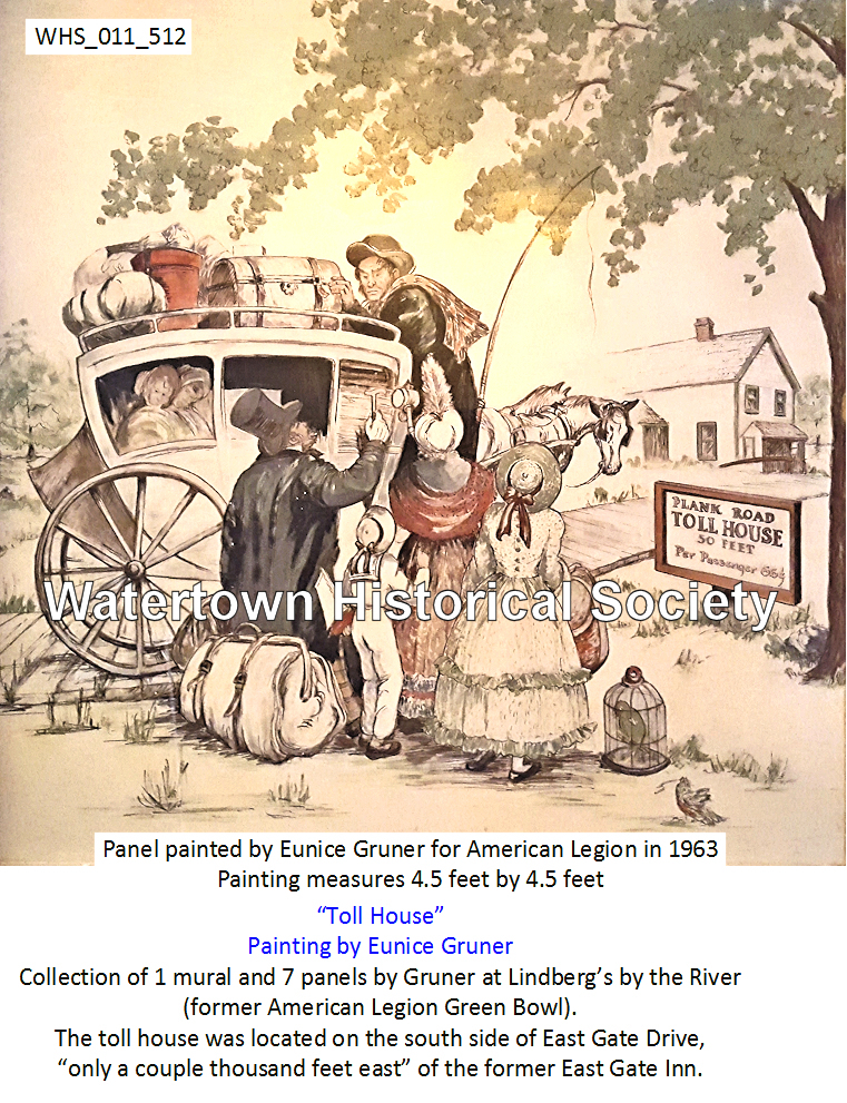
click to
enlarge
Watertown Plank Road
Johnson's Rapids (Watertown), Ixonia and Pipersville
[Derived from the book "Heritage
of Ixonia. 1976. The Bicentennial Year" ]
Benjamin Piper was an adventurist pioneer who left New York in 1835 and settled on a parcel
of land that he claimed near Milwaukee. At that time Milwaukee consisted of
five or six frame dwellings, a small tavern, fifteen or twenty log cabins and
one or two grocery stores. The following spring he went to New York for his
family, to live with him on the land he claimed. In 1837 he ventured to the
Rock River country which brought him to Watertown where he found a few log huts
along the river occupied by settlers who were also seeking prospects (land to
be claimed). He then made a claim on some land above Johnson's Rapids,
located near the present sight of the Bethesda Lutheran Home in Watertown.
He then went back to his home and family near Milwaukee. A few months
later he revisited his claim in Watertown with his two sons Harrison and
Elijah. They built two log cabins, one for an old friend, a Mr. Adams,
and one for himself. Having gone back again to his family near Milwaukee, he
disposed of his claim there, brought his family and settled in section 30,
which was then known as Watertown. He purchased land from the U.S. government
on August 20, 1839, (now known as the Claude Hauser farm) and was considered
the first settler in the southwestern part of the township now known as
Pipersville, which was named after the Piper family.
In 1837 a road opened from Johnson's Rapids to Milwaukee called
the Plank Road. Mr. Piper was impressed with this road and built an inn
on his property serving the farmers that hauled grain they raised to the
nearest market, which was Milwaukee. The Plank Road was a highway on which a
team could haul twice as much as it could on a muddy wagon trail. Farmers
brought small loads of grain to a large platform which Mr. Piper built. Here
they were combined into larger loads and hauled to Milwaukee on the Plank Road.
Many times buffalo robes were used by the farmers who slept on the floor by the
fire place because the inn was so crowded. Mr. Piper was an unofficial postmaster,
and it is said that Mr. Piper used a wash stand drawer in a back room as post
office facilities.
Jonathon Piper came to Pipersville in 1847. Depending on power furnished by the dam
which extended across the Rock River to a small island, he soon built and
operated a saleratus factory just south of the present bridge . . .
. . . The coming of the railroad was responsible for the location and
growth of Ixonia. Ixonia Center was the common name given at that time.
In its infancy there were two stores, a saloon, one blacksmith shop, one
turning shop, two shoemakers, a cheese factory, a grain elevator, a church and
a public school.
In 1922 the plank road was relocated from its location
south of the railroad tracks to the north of the tracks. It has been the main route through Ixonia
from its very beginning and was later called Highway 19. A street leading to
the north from Highway 19, in the village was another established busy
street. In 1924 Highway 19
was widened to 24 feet and paved. A curb, gutter, and storm sewer were
installed. The storm sewer being financed 100% by the state because it was a
state road at that time. The village homes and businesses were established on
both sides of the two streets, now called Marietta Avenue and North Street. The
village experienced heavy traffic from the east to the west passing through
continuously until 1956, when Highway 16 was rerouted to bypass
the town . . .
. . . To open the country for settlement and military purposes, new
routes for traveling became a necessity. Many old Indian trails were replaced
by wagon roads. A wagon road which today creates a special interest to the
Ixonia township is the road constructed in 1837, which was later planked and
called the Plank Road. On a historical marker erected in 1956 located
approximately one-half mile east from the center of the village, the following
information may be read. "In 1917, the Wisconsin Highway Commission
engineers recommended and inaugurated with the Legislature's authorization, the
first statewide system of identifying highways by number. This highway was
designated State Trunk Highway 19 (later U.S. 16) and was the first to be
marked and signed by numerals. The now familiar number system was later adopted
by all other states and many foreign countries" . . .
. . . In the early 1900's, new road beds were made by pulling a heavy
reversible road machine by a team of six horses; and to maintain them, a small
grader drawn by two horses was used. The winters were extremely difficult in
the pioneer days. The deep snow in the roads was avoided by making a trail off
the road, around the banks, and through the fields, cutting the fences when it
was necessary. Again, manual labor and
shovels were used to take away the snow to such an extent that the road
equipment available in those days could then handle it. When the snow built up
between the wagon tracks, a one horse walking plow was mounted to the side of a
bob sled runner, turning the snow out of the track. This also loosened the snow
for better driving conditions. After the snow disappeared, a mud problem was
created by the freezing and thawing conditions. Often times stones were filled
in some of the mud holes in the roads and road drags were used to level off the
road beds.
With the intent to improve the Watertown Plank Road, a stone crusher was
purchased in 1914. A year later the east end of the plank road to the village
was surfaced with crushed stone and oil. In 1917 the west end was surfaced in
the same manner. One half of the expense of both projects was funded by the
state. The distance to improve these two sections of road was determined by the
amount of funds available. In 1922 the highway was relocated from south of the
railroad tracks to the north side, now a street through Ixonia. More stone
crushers were purchased and soon disposed of because of continuous break downs
. . .
Information from 1948 Milwaukee Sentinel article by August
Derleth
Additional annotates by Bill Jannke
Because of its proximity to Milwaukee the growing settlement of
Watertown seemed a logical terminus for a road as well as for a railroad.
During the decade of the 1840's the Territory of Wisconsin, moving toward
statehood, drew settlers from the east and from foreign countries. It became
necessary to construct serviceable roads in place of the wild trails which were
often impassable and imposed much hardship on travelers in Wisconsin.
The first agitation was, naturally, for such water traffic was
possible, and for construction of canals to further that traffic. But waterway travel was not practical into
many parts of Wisconsin, and it did no permit the movement of large numbers of
people and their belongings. The next agitation was for plank roads, and the first of these roads
was constructed to Watertown from Milwaukee in 1847, at a cost of $119,000.
This was a toll road, and a toll house stood in Watertown after its completion
in 1850.
Meanwhile, however, even as plank roads were being built, the iron
horse was preparing to invade Wisconsin. In the very year of the beginning of
the Milwaukee-Watertown plank road,
a charter was granted to the Milwaukee and Waukesha Railroad Co. By 1855 the
Milwaukee Road had reached Watertown. And in November, 1859, the Janesville and
Fond du Lac branch of what is now the NorthWestern Road, ran its first train
into Watertown.
The coming of the railroad was accompanied by an amusing incident
when Michael O'Hara, the engineer of a locomotive approaching Watertown, not
convinced that the two mile bridge east of Richards' Cut near Watertown would
support his locomotive, started the engine, then jumped off at the head of the
bridge, letting the locomotive go over alone to be caught on the far side by
the waiting firemen.
The Plank Road and the railroad connection Watertown with
Milwaukee played an important part in the growth of the settlement along the
Rock river. The waterpower at the site
was soon harnessed for other saw mills and for factories to make carriages,
barrels, wagons and firkins. Even before these connecting links to the port
city of Milwaukee, Watertown was being settled by German immigrants, many of
whom were political refugees who had been university students and men in
professions for which there was as yet no need in a new settlement like
Watertown. As a result, for many years everything these men turned their hand
to was a failure; they could not make shoes, they could not manufacture cigars,
they could not even brew. When they congregated at the
Buena Vista House, they habitually conversed not in German, but in Latin, as a
result they were locally known as "Latin Farmers."
1848
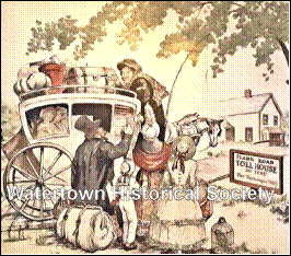
-- -- STAGECOACH STOP ON THE WATERTOWN PLANK ROAD
The
award-winning Red Circle Inn & Bistro, N44-W33013 Watertown Plank Road,
Nashotah.
“The Red Circle Inn was a stagecoach stop on the Watertown Plank
Road between Milwaukee and Watertown,” said owner Norm Eckstaedt. It is Wisconsin’s oldest restaurant,
according to Eckstaedt, who purchased the restaurant
in 1993 with his wife, Martha. Opened in
1848 as the Nashotah Hotel, it became the Red Circle Inn in 1889 when beer
baron Fredrick Pabst renamed it after the brewery’s logo. “Waukesha County Historical Society files
list the Nashotah Hotel on an old stagecoach schedule from 1852,” Eckstaedt said. jsonline.com
article
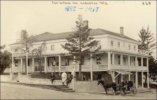
A 1910 postcard shows The Red Circle
Inn in Nashotah with the “Pabst Milwaukee” round logo over the sign at
left. (Photo: Wisconsin Historical Society)
04 16 We see by the Chronicle that the coaling and planking of the plank road from
here to Milwaukee, has been put under contract and that there is a fair
prospect of finishing it through this summer.
Success to the undertaking, for our faith waxes stronger in favor of
these "Farmers' Railroads” every day, and we are satisfied that they will
be of more benefit to Watertown and the adjacent country, than any railroad
that can be built. By the way, what has
become of the plank road from the Crawfish to Watertown? We understand and that it would intercept
much of the travel that now goes south of us, and from the information we have
of that portion of the country, we are induced to think no road will pay better
than to that point. Watertown Democratic State
Register
1852
04 14 The
Watertown and Milwaukee Plank Road Company has declared another dividend of 3
per cent, making 10 per cent since the first of January. Think of this, ye who_?_ 40 per cent annually
for the use of your money; and then act like wise men - purchase stock in the
Watertown, Hubbleville, Portland and Waterloo
road. WC
1853
06 04 Our
Plank Road -- We are now in connection, for the first time, with Milwaukee by a
plank road, the gap having been finished
today so that our friends can travel from Milwaukee to the new bridge in
our city without getting off the plank.
From the bridge west the planks are being hauled, and we hope it will be
finished within the next ten days. Democrat State Register
06 18 Plank
Road Notice -- The meeting for the annual election of Directors of the
Watertown & Waterloo Plank Road Co., is advertised in today's paper.
1854 CARL SCHURZ ARRIVES IN WATERTOWN (via Plank Road)
-- -- Going west to St.
Louis, Carl Schurz wrote: "I am taking a lot
of notes and having many experiences which will come in handy. I am more and
more convinced that we should be on easy street here in a couple of years. . .
." So it seems he was positively bent on getting rich quickly. When he
reached Chicago on his return trip he found letters from his uncle, Jacob Juessen, who urgently invited Schurz to visit him and his
family at Watertown, forty miles west of Milwaukee. He must have had such a
side excursion in mind, for the uncle's letters were doubtless in response to
suggestions of his own; otherwise the time of his arrival in Chicago would not
have been known. On that trip he experienced for the first time the natural
charms and material enticements of southern Wisconsin. The beautiful moonlight
voyage on Lake Michigan by boat from Chicago to Milwaukee prepared him for a
cheerful, but not quite openminded appraisal of the Badger metropolis. He found
the combined rail and stage ride to his destination enjoyable rather than the
reverse, a "splendid plank road" contributing to his satisfaction.
Schurz was impressed with all he saw, calling Wisconsin a beautiful land. The
development of the southern part of the state surprised him; he had expected to
find it less well settled. It was already a fine, prosperous farming
region. From “Margarethe Meyer Schurz – A Biography”
by Hannah Werwath Swart, reprinted by the Watertown
Historical Society and is now available in two formats, ebook
and soft cover.
11 16 8000 FEET OAK PLANK
Meeting of the City Council, November
13th, 1854... Resolved, That the Street Commissioners of the 3rd and 4th wards
be, and they are hereby authorized and directed to procure 8000 feet oak plank,
for the purpose of finishing up the Plank Road, on West Avenue Street to where
the Watertown and Portland Plank Road commences, and that the expenses of the
same be paid out of the City General Fund.
WD
1858
11 18 Obligation to repair the plank road
bridge WD
1859
02 10 PROPOSAL:
HIGHWAY TO REPLACE PLANK ROAD
Ald. Dutcher introduced a
memorial praying the Legislature to vacate so much of the charter of the Milwaukee
and Watertown Plank Road Company as lies between Watertown and Oconomowoc and
establish the same as a Public Highway.
Also, Resolved, That the City Attorney be and he is hereby instructed to
commence legal proceedings immediately against the Milwaukee and Watertown
Plank Road Company for suffering the bridge
in this city upon said road to become impassable by the traveling
public. Common Council Proceedings, WD
1861
04 03 PLANK ROAD DECLARED A PUBLIC HIGHWAY
April
3 1861 - AN ACT to establish a Highway.
The line of road of the Madison Watertown and Milwaukee plank road
company, including their road bed between the city of Watertown and the village
of Oconomowoc, having been abandoned by said company is hereby declared and
established as a public highway and subject to the management and control of
the town or city in which the same lies like other highways SECTION 2 This act
shall take effect and be in force from and after its passage. Approved March 29 1861
1907
01 23 SIDEWALK ALONG PLANK ROAD
Editor Leader: The people living on the Plank Road in the
Mecklenburg settlement are kicking vigorously because of the indifference of
the common council to their needs and convenience. For thirty seven years they had sidewalk, but
about two years ago it was torn up by order of the council, since which time
they have been obliged to wade through mud when the weather was rainy and their
children remain out of school at such times.
They have repeatedly asked the council to order the side walk restored
but no attention has been given to their request, and they feel that they have
just cause for complaint, and that the city authorities should give them the
attention the conditions demand. It is a
matter that should be investigated by the mayor and common council at the
earliest possible moment and action taken in giving the people living out on
the Plank Road a sidewalk.
Yours respectfully, Meckelburger [Mecklenburger]
c.1920
VIEW TO THE EAST FROM OCTAGON HOUSE
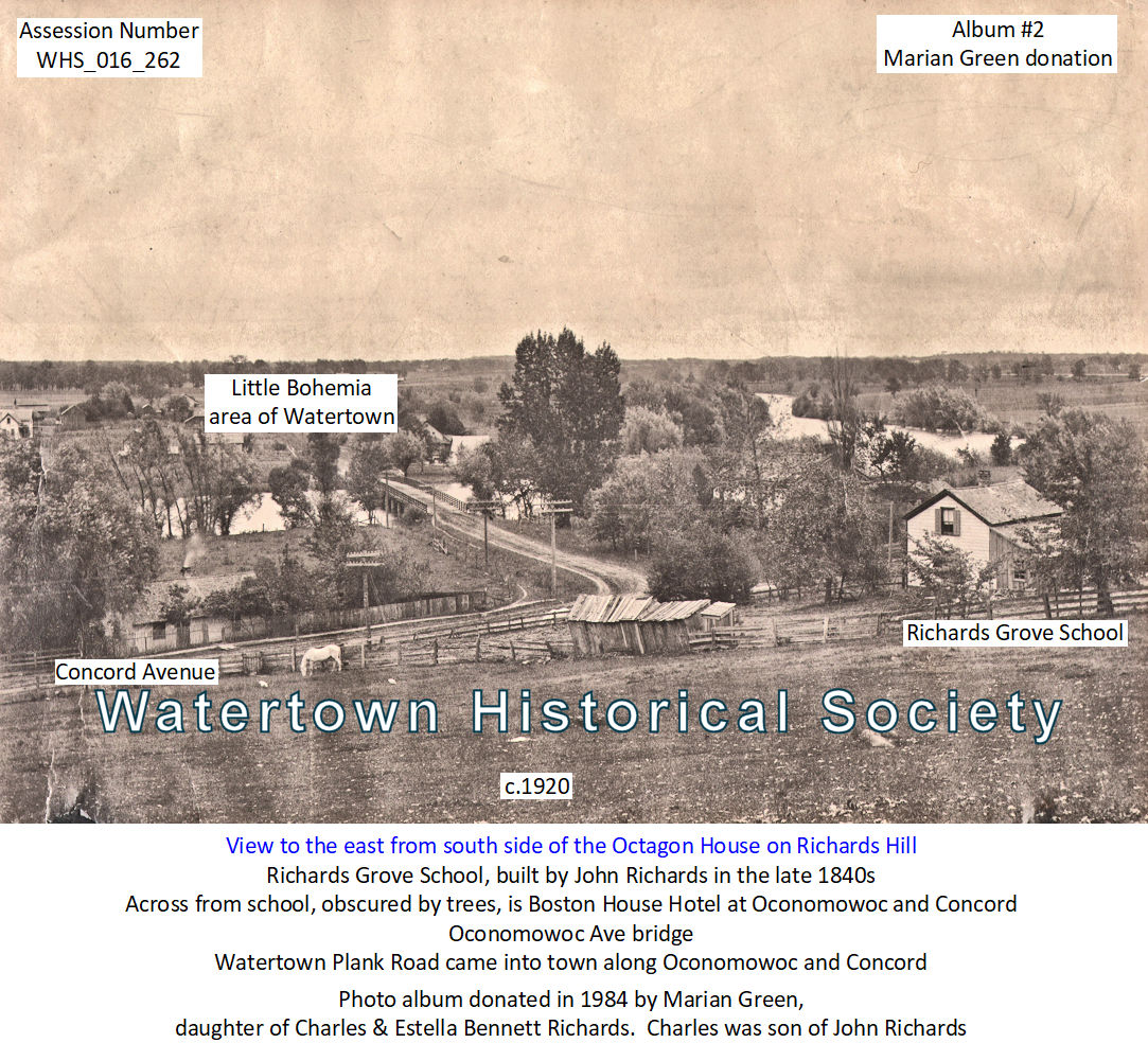
Oconomowoc Ave bridge
Richards Grove School, built by
John Richards in the late 1840s
Watertown Plank Road came into
town along Oconomowoc and Concord avenues
Boston House Hotel
Little Bohemia area of Watertown
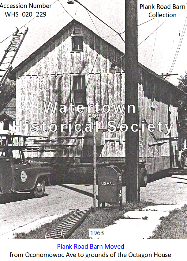
1963
PLANK ROAD BARN MOVED
TO GROUNDS OF THE
OCTAGON HOUSE
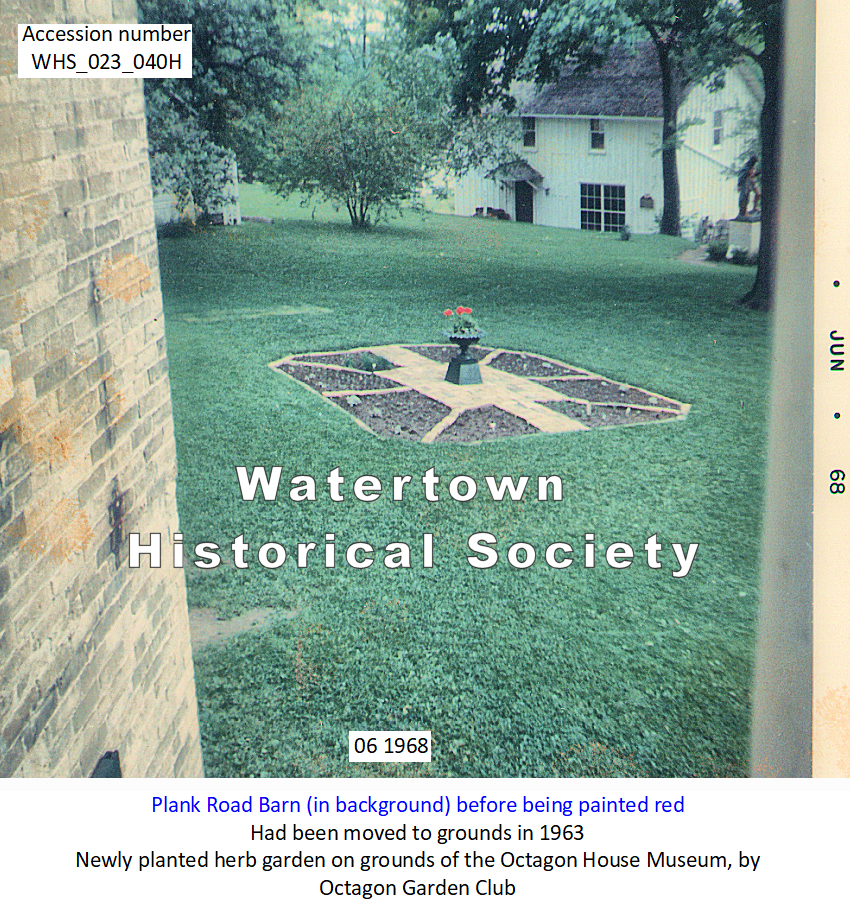
1968
PLANK ROAD BARN before being
painted red
Cross References to WATERTOWN-PORTLAND PLANK ROAD:
No 1:
Daniel Jones was one of the originators of the Plank road, between
Portland and Oconomowoc, and it was a
good investment until the railroads came through. They ruined the business and I lost what I
had in the enterprise.
No 2:
1871 note on road condition: On the Watertown road but it is quite sticky.
No 3:
Mud Tavern hostelry on plank road
No.
4: 1998, Covered wagons once
again rumbling down the old Watertown Plank Road.
Plank road vs railroads
WC 02 23 1848, p2
WC 03 08 1848
WC 02 16 1948. p2
WC 04 19 1848, p1
WC 04 26 1848, p1
WC 01 05 1848, p1, p3
Watertown Plank Road Barn
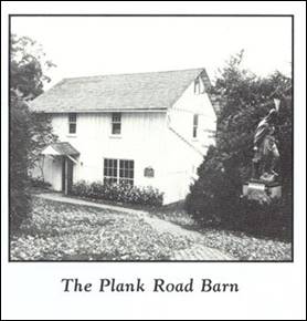
The Plank Road Barn was
originally located along the Watertown-Milwaukee Plank Road a short distance
east of its present site on the grounds of the Octagon House.
Moved to the grounds in the
1960s, it now houses a collection of pioneer tools and farm implements.
ARTICLE:
pdf
article on the Plank Road Barn (Pioneer Barn)
![]()
History of Watertown,
Wisconsin